-

Caption Text
Link -
Caption Text
Link -
Caption Text
Link -
Caption Text
Link -
Caption Text
Link -

Caption Text
Link -
Caption Text
Link -
Caption Text
Link -
Caption Text
Link -
Caption Text
Link
Edom Lowlands Regional Archaeology Project
The Edom Lowlands Project: Iron Age State Formation In Southern Jordan, ca. 1200 500 BCE.
This study of Iron Age state formation in southern Jordan is deeply rooted in three conceptual frameworks: a) general anthropological theory concerning processes of secondary state formation and the evolution of social power, b) historical models concerning the Iron Age based on Anthropology, Biblical and extra-Biblical sources, and c) Middle Range theory that aims at linking raw archaeological data with more complex generalizations and conclusions about the past based on the hard archaeological evidence retrieved from the 2006 excavations at Khirbat en-Nahas (KEN) one of the largest ancient copper production sites in the eastern Mediterranean. To test these models, the control of time (to measure social change) and space (the context in which artifacts are discovered) are critical. This project achieves this though the application of high precision radiocarbon dating and statistical modeling and the use of a Geographic Information Systems (GIS)-based Digital Archaeology system. The GIS system also promotes rapid publication and the dissemination of project results.
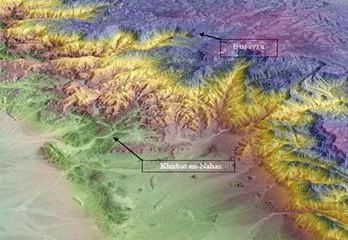
The Highland Lowland Dichotomy in Iron Age Edom, Jordan. The distance between Khirbat en-Nahas (KEN) and Busayra is approximately 20 km as the crow flies. KEN is located in the lowlands, at an elevation of ca. 83 meters above sea level (masl) in the copper ore rich Faynan region. The environment is characteristic of the Saharo-Arabian desert zone with less than 60 mm average annual rainfall. Busayra is situated in the highlands of Edom at ca. 1140 masl in the semi-arid Irano-Turanian vegetation zone, with average annual rainfall of ca. 200 350 mm and suitable for dry-land farming. The false color 3-D satellite image of the Edom Lowlands research area on the right highlights the radical environmental differences between the highland and lowlands of Edom. Satellite image courtesy of R. Cleave (RHOR Publications, Nicosia).
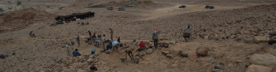
To date, researchers have not solved the problem of who controlled metal production at this key Levantine site during the Iron Age a period that follows the collapse of many of the Late Bronze Age civilizations in the eastern Mediterranean region. Recent field work at KEN and limited AMS radiocarbon dating have pushed back the dates for the Iron Age in Edom some 200 to 400 years earlier than previously thought (Levy et al 2004, 2005; Higham et al 2005). This has opened up new research questions that challenge models that explain the emergence of the Edomite state (i.e. core-civilization (Assyrian) dominance over Edom vs. local peer polity interaction with neighboring statelets such as Israel, Judah, Moab and others). To adequately test these models, excavations are needed to retrieve data that can inform on the ethnic identity of those who controlled metal production at the site. Thus, the 2006 work is a diachronic interdisciplinary study that aims to: a) complete the excavations of the KEN 4-Chamber gate a hallmark signature of 1st millennium BCE military architecture, b) sample the interior of the fortress for evidence of social organization at the site, and c) sample a large building associated with intensive smelting activities to help reconstruct the social dimensions of metal production at the site.
As Khirbat en-Nahas is located in Jordans premiere Dana Nature Reserve administered by the Royal Society for the Conservation of Nature (RSCN), this project will contribute to their regional development plan for this part of Jordan. The project also serves as the UCSD Middle East archaeological field school that trains undergraduate students, graduate students and members of the Department of Antiquities of Jordan in the most current aspects of archaeological method and theory.
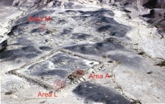
Aerial view of Khirbet en-Nahas with 2006 excavation areas highlighted for Areas A, L and M. The black areas represent thick deposits of Iron Age slag.